 WhatsApp
 Twitter

Utah has landscapes that feel hidden in plain sight. These hidden places in Utah include sandstone caverns, isolated ridges, lava-carved caves, and formations shaped by wind and time. You won’t find big signs or viewing decks here. Some are known only through word of mouth or old trail notes, and the paths are quieter, the surroundings more raw. Reaching them might involve dirt tracks or long walks, but they reveal a side of Utah that’s deeply personal. For travellers who want to escape the expected and explore what’s left untouched, these locations are where the real adventure begins.
Discover 10 Hidden Places In Utah
Each place in this list offers something distinct, from remote rock tunnels to colourful cliffs. These lesser-known hidden places in Utah show a wilder and quieter side of the landscape.
1. Fifth Water Hot Springs

Photo: The Dye Clan / Wikimedia Commons
Among the lesser-known places in Utah, Fifth Water Hot Springs lies beyond a 2.5-mile trail in Diamond Fork Canyon. The hike begins near a gravel turnout and follows a clear stream bordered by rocky ledges and light forest. Along the way, you’ll pass small waterfalls before reaching a cluster of natural pools. \Mineral deposits give the pools a soft blue colour, and the scent in the air hints at the sulphur content. Visitors often alternate between the warm pools and the cold creek for contrast. Spring and autumn offer the best conditions, though winter adds snow-covered views.
How To Reach: Reach the trailhead via Diamond Fork Road, then hike 2.5 miles each way.
Best Time To Visit: April – June & September – October
Nearby Attractions: Spanish Fork River Trail, Diamond Fork Arch
2. Reflection Canyon
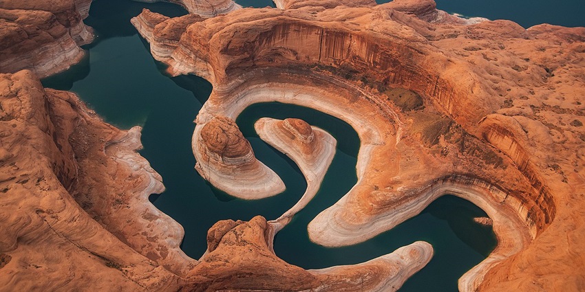
Photo: Jay Huang / Wikimedia Commons
Reflection Canyon lies in the Glen Canyon region and is shaped by layers of Entrada sandstone carved over millions of years. The water seen in the canyon is part of Lake Powell’s arm, which fluctuates depending on seasonal runoff. The rock surface around the rim is marked with fossilised ripple marks and cross-bedding lines that indicate its ancient origin beneath an inland sea. The terrain is bare and dry, with no trees or cover, and strong winds are common.
How To Reach: Access via Hole-in-the-Rock Road, followed by an intense 16-mile round-trip hike.
Best Time To Visit: March – May & September – October
Nearby Attractions: Lake Powell, Coyote Gulch
3. Moonshine Arch

Photo: Bernd Thaller / Wikimedia Commons
Moonshine Arch sits in a quiet sandstone bluff north of Vernal and offers one of the more unusual rock formations in eastern Utah. This long, curved opening measures approximately 85 feet wide and stands nearly 40 feet tall, but is tucked away with little signage or promotion. Unlike most formations in the region, Moonshine Arch is accessible by a short, mostly unmarked trail that starts from a rugged dirt road north of town. The arch sits above a sheltered alcove, and on clear mornings, the rock glows with soft gold and rust tones.
How To Reach: North of Vernal; drive gravel road, then walk a short 0.8-mile trail.
Best Time To Visit: April – June
Nearby Attractions: Red Fleet State Park, Utah Field House
4. Valley Of The Gods

Photo: John Fowler / Wikimedia Commons
Valley of the Gods lies near Mexican Hat and is often mistaken for a smaller version of Monument Valley, but without the traffic or tour buses. This stretch of isolated land features freestanding red rock towers, mesas, and buttes shaped by time and wind. The 17-mile unpaved loop that winds through the area gives changing views at every turn; some formations rise like stone ships, and others resemble weathered spires. Navajo stories still surround some of the formations, and their names, like Sitting Hen and Rooster Butte, reflect both shape and local memory. As one of the most open hidden places in Utah, the silence here stretches across miles of empty landscape.
How To Reach: Scenic drive off Highway 163 near Mexican Hat; high-clearance vehicle recommended.
Best Time To Visit: March – May & October – November
Nearby Attractions: Goosenecks State Park, Monument Valley
5. Yellow Rock (Grand Staircase-Escalante)

Photo: Greg Willis / Wikimedia Commons
Tucked above the Paria River Valley in Grand Staircase-Escalante, Yellow Rock is a dome of swirling sandstone unlike anything else in the region. Its surface is a patchwork of yellow, orange, pink, and cream, formed by oxidised iron minerals and ancient sediment layers. The rock rises above Cottonwood Canyon, and its tilted slope reveals exposed cross-bedding lines that make it a favourite for photographers and geologists. Reaching the formation requires a steep climb over loose sand and slickrock, but the payoff is a panoramic view of Cottonwood Narrows and the Cockscomb ridge.
How To Reach: Drive along Cottonwood Canyon Road, then hike 1.5 miles to reach the viewpoint.
Best Time To Visit: April – June & September – November
Nearby Attractions: Grosvenor Arch, Kodachrome Basin
6. Little Egypt Geologic Site

Photo: ArtTower / Pixabay / Image For Representation Only
Little Egypt is located 5 miles off Utah Route 276 and is known for its group of hoodoos formed from Entrada sandstone, the same type found in Arches National Park. The formations vary in height, some under four feet, others close to twelve, and have layered caps that rest on narrower bases. This site covers a small area and can be explored in under an hour. The surface is loose and uneven, with scattered shale fragments. Little Egypt remains one of the most unusual hidden places in Utah, often visited by geology students or photographers.
How To Reach: Off Utah Route 276, 5 miles along a dirt road near Hanksville.
Best Time To Visit: March – May & October
Nearby Attractions: Factory Butte, Goblin Valley State Park
7. Bloomington Cave

Photo: Manju Raj / Pexels / Image For Representation Only
Bloomington Cave is located in the Beaver Dam Mountains west of St. George and is one of Utah’s few publicly accessible wild caves. Spanning over 1.4 miles, the cave system is a twisting network of narrow passages, steep drops, and irregular chambers formed in limestone fault zones. The air inside remains cool year-round, and the walls are marked with mineral deposits, old flowstone, and patches of dried mud. Some routes require crawling or rope assistance, making it suitable only for physically fit explorers.
How To Reach: 15 miles west of St. George; access via dirt road. Permit required.
Best Time To Visit: April – May & September – October
Nearby Attractions: Snow Canyon State Park, Anasazi Valley Trail
8. Granary Ruins (Moab)

Photo: Bureau of Land Management / Wikimedia Commons / Image For Representation Only
Above Kane Creek Boulevard in Moab, a cluster of stone storage rooms built between 700 and 1200 CE still sits in a shallow rock alcove. These granaries were constructed by the Ancestral Puebloans using carefully stacked sandstone and clay mortar, designed to keep seeds and dried crops safe from moisture and animals. The ruins are elevated above the ground and partially hidden under an overhanging ledge. From the roadside, they appear small, but a short scramble uphill reveals the tight stonework. A few faded petroglyphs can be seen on the surrounding wall panels, mostly abstract shapes and lines.
How To Reach: Short hike off Kane Creek Road southwest of Moab
Best Time To Visit: March – May & September – November
Nearby Attractions: Moonflower Canyon, Colorado River
9. Yant Flat (Candy Cliffs)

Photo: John Fowler / Wikimedia Commons
Yant Flat, known locally as the Candy Cliffs, is a stretch of Navajo sandstone formations located on the southern edge of the Pine Valley Mountains. The surface here twists into wave-like ridges, domes, and terraces coloured in streaks of orange, red, and pale pink. The layered appearance is the result of iron oxide deposits that settled unevenly during the Jurassic period. As one of the most visually unique hidden places in Utah, Yant Flat offers dramatic terrain without crowds, drawing landscape photographers, hikers, and geology enthusiasts.
How To Reach: Drive Forest Road 031 near Leeds, then hike around 2 miles
Best Time To Visit: March – May & October – November
Nearby Attractions: Snow Canyon Overlook, Red Cliffs Desert Reserve
10. Belly Of The Dragon

Photo: inkknife_2000 (7.5 million views +) / Wikimedia Commons / Image For Representation Only
Belly of the Dragon is a man-made drainage tunnel carved through a sandstone ridge just south of Mount Carmel Junction. Originally built to divert water beneath Highway 89, it has since become a little-known stop for those exploring the area. The tunnel is about 200 feet long and features textured, rippled walls caused by water erosion over time. Visitors can walk through it in minutes, but the visual effect is what leaves an impression. The floor is rocky and uneven in places, especially after recent rains.
How To Reach: Off Highway 89 near Mt. Carmel Junction, a short 0.5-mile walk
Best Time To Visit: April – June & September – October
Nearby Attractions: Coral Pink Sand Dunes, Kanab Sand Caves
The hidden places in Utah listed here offer more than quiet, they hold details you won’t find on signs or in crowded parks. These landscapes, shaped by erosion, water, and history, are still open, still changing, and still mostly overlooked. If you’re ready to go beyond the usual routes, plan your journey with TripXL today and include the corners others miss and places that leave a stronger mark.
Cover Photo: Ken Xu / Wikimedia Commons


